By: Julián García-Walter, Pronatura Noroeste
Every year, more than one million shorebirds travel along the Pacific Flyway through northwest Mexico. During their journey they use dozens of estuaries, beaches and coastal wetlands to feed and rest. With 14 WHSRN sites in northwestern Mexico, the importance of this region for shorebirds is unquestionable. Despite this, there are still huge information gaps about how the shorebirds use these sites. How do they use the chain of coastal wetlands in Mexico? When do they arrive and when do they leave from each site? How many of them survive? In the face of multiple pressures generated by human activity and presence, exacerbated by climate change, these information gaps limit our capacity to focus our conservation efforts where and when they are most needed.
A collaborative solution
In response to these unknowns, diverse academic institutions, conservation organizations and ornithologists from northwestern Mexico have joined together, with the support of multiple funders* to collaboratively track the movements of the birds through the region. To do so, Pronatura Noroeste coordinated the installation of the first automated monitoring network Motus in Mexico and the Pacific coast of Latin America.
To date more than 500 Motus stations have been installed throughout the Americas. Each station is composed of several antennae that can detected the movements of birds marked with minute radio-transmitters. After detection by the antenna, a tiny computer records it and sends signals to a central database where users can access the data. Although Motus is well-established on the Atlantic coast, so far on the Pacific coast stations have only been installed in Canada and some US states.


Left: Western Sandpiper (Calidris mauri) marked with a radio-transmitter (nanotag). Photo: Juanita Fonseca. Right: Motus Station. Photo: Julián García-Walter.
This year 20 additional stations have been installed in 15 priority coastal wetlands for shorebirds in northeast Mexico, 12 at WHSRN sites. The first four stations activated are at Bahía Todos Santos (Baja California), Santa Clara Gulf (Sonora) and Guerrero Negro (Baja California). Although each partner will tag different shorebird species, the installed stations will be shared and increase the local capacity for tracking the shorebirds. The Motus network in Mexico will cement international collaborations, linking for the first time hundreds of stations in reproductive and resting sites in Canada and the USA, with the non-breeding areas in Mexico.

From local threats to hemispheric challenges
Guided by the Pacific Americas Shorebird Conservation Strategy, the Motus network will be used by scientists and conservationists to generate robust data that will help combat the pressures that threaten shorebirds.
For example, at the regional level the accelerated expansion of aquaculture has resulted in the loss of critical habitat for shorebirds. Juanita Fonseca (Manomet – Coastal Solutions) will use the Motus stations to understand the movement of shorebirds between the shrimp farms. Juanita is working to design better industry practices that will generate a balance between the need for economic development of the farmers and the alternative habitats that these productive systems offer.
At the site level, Liliana Ortiz (ProEsteros) and Medardo Cruz (Coastal Solutions) will use the Motus network to monitor the breeding season of Snowy Plovers (Charadrius nivosus) which nest on the sandy beaches of the WHSRN sites Bahía Todos Santos, San Quintín, and Playa Ceuta. With just one Motus station installed strategically close to the nesting zones, they can make automated recordings in real time of data such as survival, and arrival and departure dates of marked birds.


Left: Shorebirds feeding at a shrimp farm at Ensenada Pabellones. Right: Snowy Plover nesting at Playa Ceuta. Photos: Juanita Fonseca.
In addition to the existing pressures, global changes, such as rising sea-levels also threaten to modify the existing shorebird habitats. For the species that are using the WHSRN site Guerrero Negro-Ojo de Liebre the future is uncertain. This raises uncomfortable questions such as Will the roosting areas and the intertidal flats for feeding be lost? and How will the birds respond to these changes? Doctoral candidate Julián García Walther (University of Carolina del Sur and Pronatura Noroeste) together with the Avian Laboratory of the Universidad Autónoma de Baja California Sur (UABCS) will use the Motus network to study the movements of the Pacific Red Knot (Calidris canutus roselaari) under different flooding scenarios. The investigators hope to be able to anticipate how the birds will respond to the changes to their habitat, and thus be in a position to design strategies that will increase the resilience of the site.
Pronatura Noroeste together with the Avian Laboratory of the UABCS maintain a shorebird and habitat monitoring program at the regional scale, covering 15 priority sites for the birds in northwest Mexico. The information generated by the Motus network will make it possible to know the migratory routes and patterns of the shorebirds from the entire region, helping us understand how these priority sites are utilized, and generating important data for the design of more effective conservation action plans that will be implemented.

Rising sea-levels threaten to flood many low-lying roost and feeding sites for shorebirds. Photo: J. García-Walter.
Collaborating Institutions:
- Pronatura Noroeste, AC
- Universidad Autónoma de Baja California Sur (Autonomous University of Baja California Sur)
- ProEsteros, AC
- Grupo de Ecología y Conservación de Islas AC (Ecology and Conservation Group of the AC Islands)
- University of South Carolina
- Coastal Solutions
* Organizations funding the work to establish a Motus network in NW Mexico include: Sonoran Joint Venture, David and Lucile Packard Foundation, USFWS -Neotropical Migratory Bird Conservation Act, Environment and Climate Change Canada, MPG Ranch.
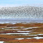
Cover Photo: Mixed flock of shorebirds feeding on the beaches of the Santa Clara Gulf. Photo: Julián García Walter.