Bahía de Santa María, located on the central coast of Sinaloa in México, became a WHSRN in August 2001. This Site of Hemispheric Importance is 50,000 hectares, with 13 swamps, extensive salt marshes, mangroves, islets, and an extensive sand bar and intertidal zone that annually plays host to more than 500,000 shorebirds and thousands of other waterbirds. In addition, this region is highly productive, providing sustenance for diverse fishing communities across the region. Pronatura Noroeste and other institutions have taken action to monitor, investigate and conserve this important wetland.


Left: Flock of shorebirds in the intertidal zones at Bahía Santa María. Right: Partners walking through the wetland zone. Photos: Juan Carlos Leyva.
Bahía Santa María has several national and international conservation designation.It is an Área Destinada Voluntariamente a la Conservación (Area Voluntarily Destined for Conservation), located within the Área de Protección de Flora y Fauna Islas del Golfo de California (California Gulf Islands Flora and Fauna Protection Area), considered a priority wetland by the Comisión Nacional para el Conocimiento y Uso de la Biodiversidad (CONABIO – National Commission for the Knowledge and Use of Biodiversity), a MAB-UNESCO World Heritage Site, and is a Ramsar Site.Nonetheless, it is an area that is highly threatened, as it is both directly and indirectly associated with the development of intense economic activities, such as agriculture, shrimp farming, tourism and fishing. The development of these productive activities has resulted in changes in the type of substrate from loamy to sandy, undoubtedly also modifying the composition of the benthic fauna at the site, and thus affecting shorebirds. In fact, the most recent censuses carried out by Pronatura Noroeste show important variations in the abundance of Western Sandpiper (Calidris mauri) and Marbled Godwit (Limosa fedoa), some of the most abundant species at the site.

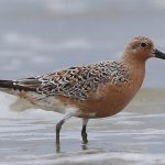
Western Sandpiper feeding. Photo: Juanita Fonseca.
On the margins of the Bahía, in the mixed inundation zones, numerous shrimp farms have been established which have fragmented the habitat and modified the hydrology of the wetland. ”Some sites that were seasonal lagoons used by shorebirds for resting, foraging and wintering no longer exist.”said Juan Carlos Leyva, Regional Coordinator of Pronatura Noroeste. “Although there is a good relationship with the producers, the development of the farms is still a threat to the ecosystem and its biodiversity.”
To protect and conserve this site, Pronatura Noroeste works in the creation and promotion of voluntary designated conservation areas. In 2014, the first certification of “Bahía Santa María Ecological Reserve” was obtained. Juan Carlos Leyva commented that ”The reserve began with a series of agreements between small property owners and, to date, there are more than 1,600 hectares (3,953 acres) voluntarily designated for conservation. Furthermore, we are continuing to work along these lines to reach agreements with more property owners so that we can dedicate more land to conservation and management.”

At the same time, work is being done to improve the wetland, with the installation of biofilters for the decontamination of strategic sites to the south of Bahía de Santa María. These biofilters were constructed by the Macario Gaxiola community, in Navolato, Sinaloa. Territorial management tools are also being promoted, such as the Navolato Municipality Ecological Ordinance, the community monitoring program, the integration of a Management Committee which includes representatives from the productive sector and the training of members of the California Gulf Islands Advisory Council (Consejo Asesor de Islas del Golfo de California) and the Cuenca Council (Consejo de Cuenca).

Bahía Santa María Ecological Reserve. Photo: Juan Carlos Leyva.
Likewise, an Integral Management Plan for the Bahía Santa María Basin is being developed, with the aim to drive forward the recuperation of the wetland, in collaboration with the Angostura City Council, the city of Navolato,the Natural Protected Areas Commission (Comisión de Áreas Naturales Protegidas – CONANP), the Sinaloa Institute of Fishing and Aquaculture (Instituto Sinaloense de Pesca y Acuacultura), the Secretariat of Sustainable Development of the Sinaloa State Government (Secretaria de Desarrollo Sustentable del Gobierno del Estado de Sinaloa), National Water Comission ( Comisión Nacional del Agua -CONAGUA) and the Council of the Basin of the Mocorito to Quelite Rivers (Consejo de Cuenca de los Ríos Mocorito al Quelite), regional producers in aquaculture and agriculture, and a number of other partners committed to conservation.
During the last two decades, Pronatura has led several research projects and participatory programs for citizens, sharing results and creating environmental awareness. This dedication and engagement of community has had a major contribution to the continued conservation of this important wetland.
For more information contact Juan Carlos Leyva (jcleyva@pronatura-noroeste.org), Regional Coordinator, Pronatura Noroeste, Sinaloa, México
Cover Photo: Panoramic view of Bahía de Santa María. Photo: Medardo Cruz-López.