Columbia River Estuary
Location
Oregon and Washington, United States
Category
Regional
Basis for Designation
Supports more than 20,000 shorebirds annually, including 3.7% of Dunlin subspecies (Calidris alpina pacifica).
Size
10,587 hectares (26,161 acres)
Date Designated
June 2009
Site Owner
Federal
US Fish and Wildlife Service – Lewis and Clark and Julia Butler Hansen NWRs
State
Washington Department of Fish and Wildlife, Coastal Washington Office
Washington Department of Parks and Recreation
Washington Department of Natural Resources (Potential participant in negotiation)
Private
Columbia Land Trust
Hancock Forest Management
The Nature Conservancy of Oregon
Site Partners
USFWS Office of Migratory Birds and Habitat Programs
Oregon Department of Fish and Wildlife
Washington Department of Fish and Wildlife
Washington Department of Parks and Recreation
Washington Department of Natural Resources
Columbia Land Trust
Hancock Forest Management
The Nature Conservancy of Oregon
Pacific Coast Joint Venture
Audubon Society of Portland
Audubon Society of Washington
Lower Columbia River Estuary Partnership (LCREP)
Columbia River Estuary Study Taskforce (CREST)
Mike Patterson

Overview
The Columbia River Estuary WHSRN Site is located from the mouth of the estuary to 60 river miles inland, along the border between the states of Washington and Oregon. The site lies within the Marine west coast climate zone with mild temperatures throughout the year. Columbia River Estuary contains some of the most biologically productive ecosystems in the world because of the large and concentrated supply of nutrients from the convergence of the Columbia River and Pacific Ocean.
The lower Columbia River Estuary has diverse intertidal habitat used by shorebirds year-round but is particularly important during shorebird migration. Each spring, on their migration northward, hundreds of shorebirds stop to rest and feed on the open mudflats in the estuary. Well-known shorebird areas include Clatsop Spit, Young’s Bay, Baker Bay, and islands of the lower Columbia River Estuary such as Rice Island and Miller Sands Islands.
The majority of lands within the WHSRN Site area are part of the Lewis and Clark National Wildlife Refuge. Julia Butler Hansen National Wildlife Refuge is also included in the site and contains over 6,000 acres of pastures, forested tidal swamps, marshes, sloughs, and islands in both Washington and Oregon. Habitat on the coastal refuges consists of tidally influenced islands, mudflats, and shoals. These areas are not intensively managed but are protected to allow natural processes to dominate the landscape.
The lower Columbia River Estuary has diverse intertidal habitat used by shorebirds year-round but is particularly important during shorebird migration.
Other lands included in the WHSRN site that are not part of these refuges include a mix of state and private lands. State lands include state parks, where management goals aim to balance human recreation values with the needs of wildlife and their environments. They also include state-owned aquatic lands (tidelands and shorelines) in Washington, where a similar balancing of human use and recreation with sensitive natural resources takes place.
Private lands owned by conservation organization such as Columbia Land Trust and The Nature Conservancy of Oregon, as well as a preserve owned by Washington Department of Fish and Wildlife, are managed to benefit fish and wildlife populations and to conduct ecological research and restoration activities. Also included in the WHSRN site are the shorelines of private timberlands. These shorelines are not actively managed but are left undisturbed.
People are keenly aware of the importance of the Columbia River Estuary for fish and wildlife. However, awareness of the importance of the site for shorebirds tends to be concentrated mostly among conservation groups, natural resource managers, and bird enthusiasts in the region, rather than the general public. Beach closures during Snowy Plover nesting season has been one highly visible management activity that has served to educate the public about these shorebirds.

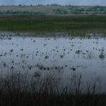
Miller Sands Island
Habitat Types and Shorebird Use
A number of different habitat types relevant to shorebirds can be found within the 60 river miles along the Columbia River. Habitat types include intertidal mud and sand flats, intertidal marshes, intertidal forested wetlands, sand/pebble shores, and estuarine waters, as well as sand dunes.
The most prevalent habitat type within the site, other than estuarine waters (which comprise the majority of the site area) is the intertidal marshes, followed by intertidal mudflats. There are a few areas comprised of inland wetlands (e.g. Julia Butler Hansen NWR). These small inland wetlands can be described as seasonal freshwater marshes. The vast majority of the site is natural in origin. The site is tidally influenced and water levels are also highly influenced by dams upriver.
More than 20, 000 shorebirds use the Columbia River Estuary each year. Species include: Black-bellied Plover, Semipalmated Plover, Killdeer, Greater Yellowlegs, Spotted Sandpiper, Whimbrel, Marbled Godwit, Ruddy Turnstone, Red Knot, Sanderling, Western Sandpiper, Least Sandpiper, Dunlin, Short-billed Dowitcher, and Red-necked Phalarope.

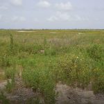
Columbia River Estuary shoreline habitat (mudflats, sloughs)
Causes of Disturbance to Shorebirds
Although the site is largely undeveloped, many activities that occur in or near the site can affect shorebirds. The major causes of disturbance to shorebirds at the site include:
- Human-caused disturbances, including recreation, excessive noise, and dogs.
- Habitat alterations/destruction and altered hydrologic regimes caused by sea-level rise, dams, dikes, removal/lack of large woody debris, and sediment accumulation.
- Altered climate and extreme weather events caused by climate change and El Nino and La Nina events.
- Potential for disturbance from oil spills.